Aircraft Tracking

  • Leader
    December 3, 2023 5:30 AM PST

    This is a linux project which includes another interest of mine which is aircraft tracking.  All aircraft broadcast an ADS-B (Advanced Directional Surveilance Broadcast) signal which includes information to enable plotting. This is used by Air Traffic Control to assist in directing aircraft.  Enthusiasts can purchase cheap equipment to connect to computers to plot aircraft local to their area on their own map displayed on a computer.  Many then share this data with organisations like Flightradar24 or FlightAware which plot positions on a map for anyone to view, thousands of enthusiasts share this data hence the aircraft are tracked worldwide. This data is also used for other research purposes.

    For this I use a Raspberry Pi computer, for size comparison I show (from right to left) a photo of a full size Raspberry Pi in a case, beside that is a smaller sized Raspbeerry Pi Zero in a case sitting on a credit card and beside that a bare board Zero.  The full sized Pi devices are priced from $35 for 1GB model, the Zero is a mere $15. All R-Pi models run a Linux operating system burnt on a MicroSD card (can run from attached USB device).

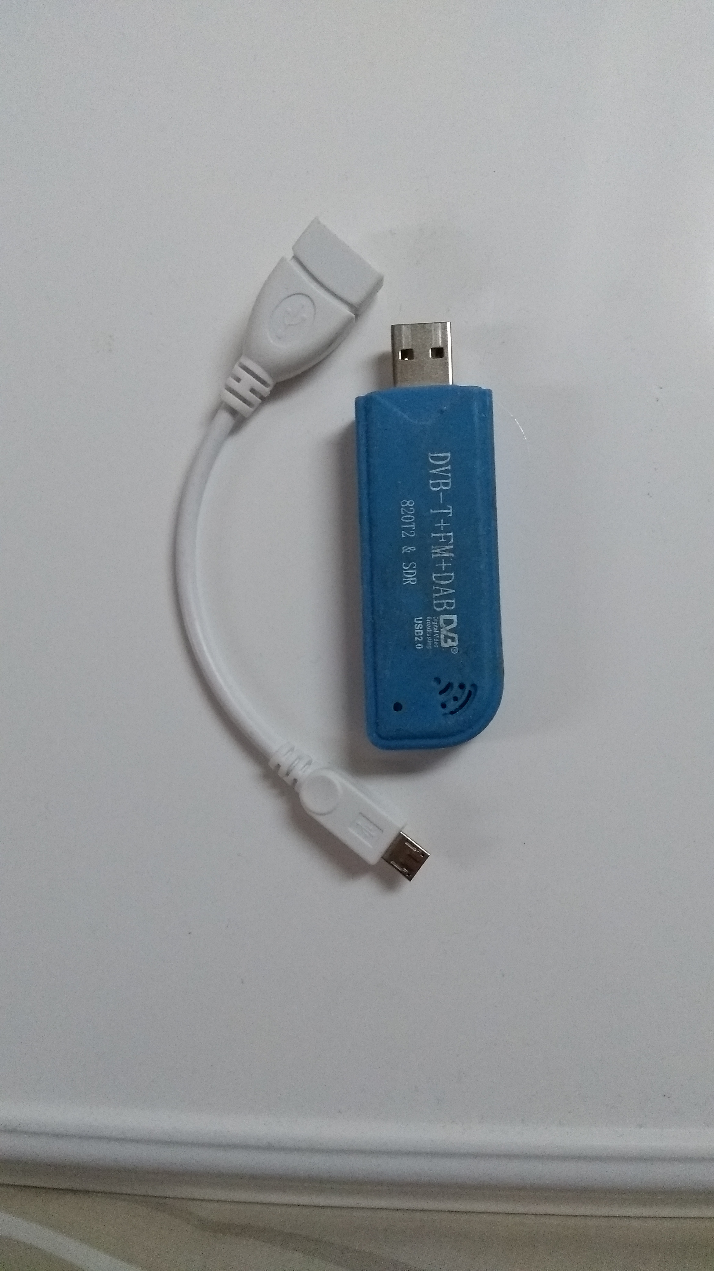
    To track aircraft a tuner needs to be purchased, these are ordinary tuners that, depending on model, can receive conventional radio channels, some get TV and for aircraft needs to include ADS-B waveband, I got mine a few years back for under $20.

    ADS-B Tunet

    How many local aircraft will appear on your map will depend on the antenna set up, mine has a magnetic base and sits on an empty tin can, this gives it stability and the can helps signal, I merely position this by a window.  Many do however have elaborate outdoor aerial.

    My Elaborate Antenna

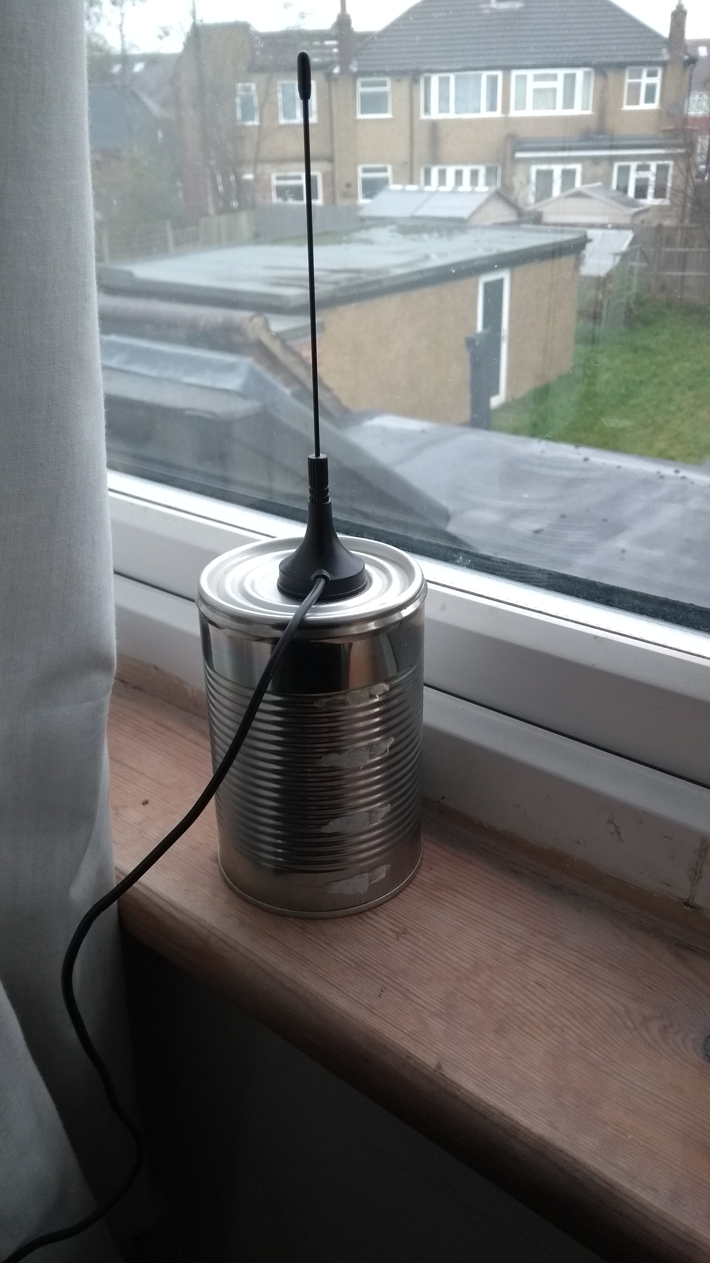
    I am very close to Heathrow as well as Luton, Stanstead and Gatwick airports so even with my basic setup my system plots around 1600 aircraft daily, my range is around 50 miles.

    To see what my system picks up view the following link, bearing in mind London is GMT and from 8pm onwards air traffic starts to die down.  It should centre on my location in North West London, mobile devices with GPS might inadvertently centre map on your phone's location.

    https://xr850.online/VRS/

    Geffers

  • Member
    December 3, 2023 7:46 AM PST

    Fascinating and thank you for all of that detail with pictures.  I can see why this is a fun hobby.  I have your map open and watching the planes activity.  Very interesting.

  • Leader
    December 3, 2023 8:50 AM PST
    Web Diva said:

    Fascinating and thank you for all of that detail with pictures.  I can see why this is a fun hobby.  I have your map open and watching the planes activity.  Very interesting.

    Where I live is on a Heathrow flight path so I regularly get aircraft passing overhead, around 8000 feet which is 1 and half miles high so not low enough to be a nuisance noise wise but low enough I can recognise aircraft and make out colours of many airlines, though from the bottom not too much insignia details.  Some Arab airlines tend to have airline name in bold lettering underneath the aircraft.

    Nice in the summer, I can see various aircraft on the map and if any of interest can be outside with binoculars.

    Geffers

  • Member
    December 3, 2023 9:24 AM PST
    Geffers G said:
    Web Diva said:

    Fascinating and thank you for all of that detail with pictures.  I can see why this is a fun hobby.  I have your map open and watching the planes activity.  Very interesting.

    Where I live is on a Heathrow flight path so I regularly get aircraft passing overhead, around 8000 feet which is 1 and half miles high so not low enough to be a nuisance noise wise but low enough I can recognise aircraft and make out colours of many airlines, though from the bottom not too much insignia details.  Some Arab airlines tend to have airline name in bold lettering underneath the aircraft.

    Nice in the summer, I can see various aircraft on the map and if any of interest can be outside with binoculars.

    Geffers

    We used to live over the DFW flight path many years ago.  We always saw and heard planes flying into and out of DFW.  When 911 happened, Bush grounded all flights and it was the quietest days ever.   We are now in a flight path to a smaller airport that does not allow international flights, however, we still see jets low enough on take off and entry.  We are prohibited in our area to use drones.

    Nice you can visually see your aircraft and with your tracking system actually verify flight details. 

  • Leader
    December 3, 2023 9:32 AM PST

    Recently used DFW for a connection flight from San Diego to Heathrow, huge airport, it was dark when I landed and the train ride between terminals was quite substantial.

    Geffers


  • Member
    December 3, 2023 11:43 AM PST
    Geffers G said:

    Recently used DFW for a connection flight from San Diego to Heathrow, huge airport, it was dark when I landed and the train ride between terminals was quite substantial.

    Geffers


    I'm glad to hear you had a good experience at the DFW airport.  DFW can be really crazy to enter from the north side at Hwy 114, or the south side from Hwy 183.  I'd say the north side is pretty challenging, lots of highways coming together.  The next challenge is always finding your right gate too.  That's always fun the way the airport is designed, OMG!